America’s roads, street signs and other public infrastructure are in dire straits. About 40% of U.S. roads are in “poor” or “mediocre” condition, according to the American Society of Civil Engineers.
What if AI can help? That’s what Blyncsy set out to do. The startup, which was acquired by Bentley Systems, provides AI-powered, real-time assessment of road conditions and public assets such as stop signs, street lights, painted lines on the road and the like.
For example, in Fort Worth, Tex., it used AI and crowdsourced street-level images from over 800,000 dash cameras to create automated near real-time view of road conditions, street lights, road signs and paint lines. It then provided this data to the city to increase public safety and efficiency of operations.
The AI Innovator caught up with Blyncsy’s founder Mark Pittman, who is now director of transportation AI at Bentley Systems.
What follows is an edited version of the conversation.
The AI Innovator: What specific AI technologies do you use to analyze and improve road infrastructure?
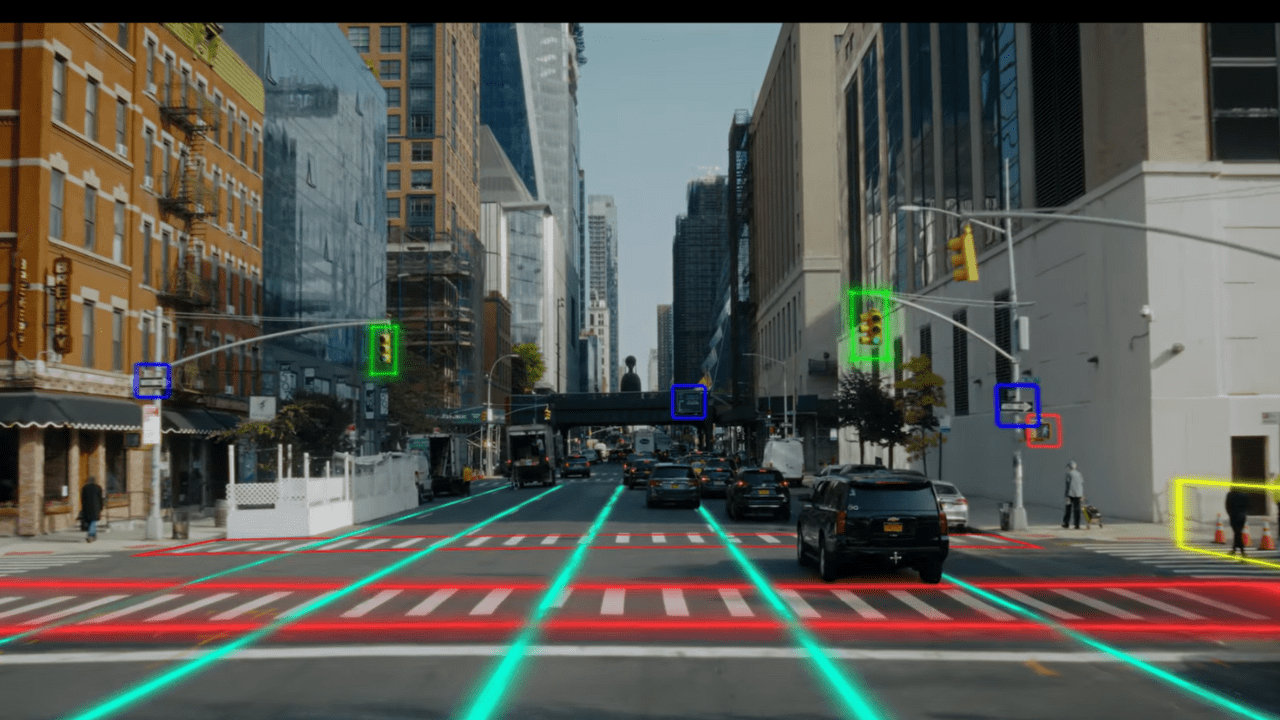
Mark Pittman: Our technology is built on trained AI models using computer vision and machine learning. Each model is trained to detect a different roadway issue, such as potholes or guardrail damage. Each model can be run on the same image, essentially allowing DOTs (Departments of Transportation) to analyze a single image for multiple road issues simultaneously.
How does your AI analyze data to identify road hazards, predict maintenance needs, or improve traffic flow?
The technology initially segments the images into various areas, such as the road surface, the areas adjacent to the roadway – sidewalks, medians or shoulders, etc. – and the area above the roadway. It can then identify issues and assets within those areas in near real-time. For asset inventory, for example, the AI can locate assets such as road signs or street lights, classify those assets – the type of sign or light – and assess the condition of the asset. For road signs, an example would be identifying damaged signs, graffiti on the sign or vegetation obscuring the sign.
This condition assessment allows DOTs to quickly locate which assets need repair. For road issues such as pavement cracking and potholes or paint degradation, our AI can classify cracking type and size of pothole, or calculate the percentage of paint remaining, so DOTs can fix these issues quickly while they are less expensive to repair.
For instance, filling a small pothole may cost less than $100, but if that pothole is ignored and allowed to grow, that repair turns into thousands of dollars to rip up the asphalt and replace an entire section of roadway. This also improves traffic as it prevents the need for these larger repair projects that may impact vehicle traffic by requiring a shutdown of that road or highway.
Can you explain how Blyncsy’s AI monitors roads in real time to enhance safety and efficiency?
Through our use of crowdsourced dash camera imagery that is continually uploaded to the cloud through mobile networks, we receive images to analyze, often within minutes of collection. The software itself is automated, so these images can be processed by our AI models instantly and insights are available in near real-time for the DOTs to inspect within the maintenance management system they are already using.
By collecting images from crowdsourced dash cameras, we are able to more frequently monitor roads, in some cases multiple times per day, giving agencies the most up-to-date information about the current conditions of their roadways.
How does your technology interact with smart city systems or autonomous vehicles?
Autonomous vehicles are just like human drivers; they rely on visual cues to navigate streets and highways safely. From using the paint lines to remain safely in their lane to using cameras to spot stop signs and lights, these vehicles rely on road assets being kept in optimal condition.
By collecting our data using cameras, we are able to assess the condition of assets and the roadway itself in a more real-world manner, helping DOTs maintain these safety-critical assets and thereby keeping all roadway users, from drivers to cyclists to pedestrians, equally safe.
What makes your AI solutions adaptable for use across different regions and budgets?
There are no upfront hardware or software costs with Blyncsy, allowing us to start a project immediately at any size. By collecting data from vehicles already on the road, we can offer a flat rate pricing per mile, per detection, and based on the frequency of the detections, allowing small cities and large state DOTs to utilize our services.
In addition, most of our AI models are trained on detections that are universal no matter the region. For instance, a pothole or crack on a road in the U.S. will look the same as a pothole or crack in India or England.
Just as our models have been trained to detect and classify road signs here in the United States, we can train our models to analyze the road signs in any country, and our software eventually will be able to detect signs autonomously based on contextual-awareness, such as knowing a sign is a stop sign based on its location at an intersection and its use of red, white and black color combinations.